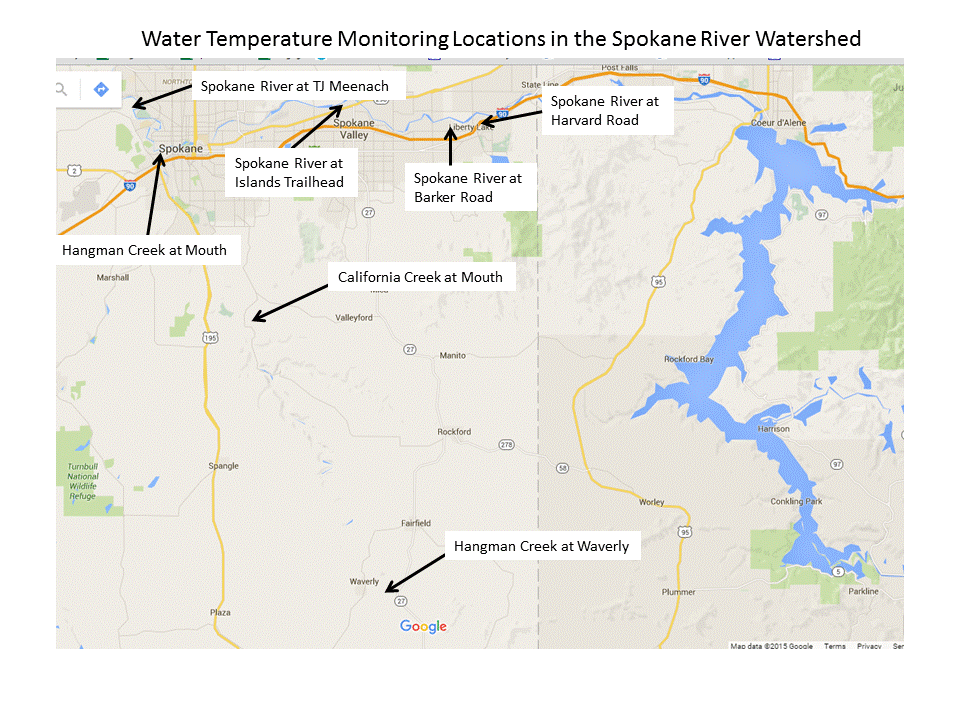
Our record breaking summer has finally ended and we have pulled our temperature loggers from the Spokane River, Hangman Creek, and the Little Spokane River (see map below). Although our water temperature program was small this year (8 locations), I think that we collected some very interesting data. I previously wrote on water temperature in the Spokane River through August, so I will primarily talk about Hangman Creek in this post. I've listed some of the highlights of our data below. Scroll down for more graphs and analysis of these data.
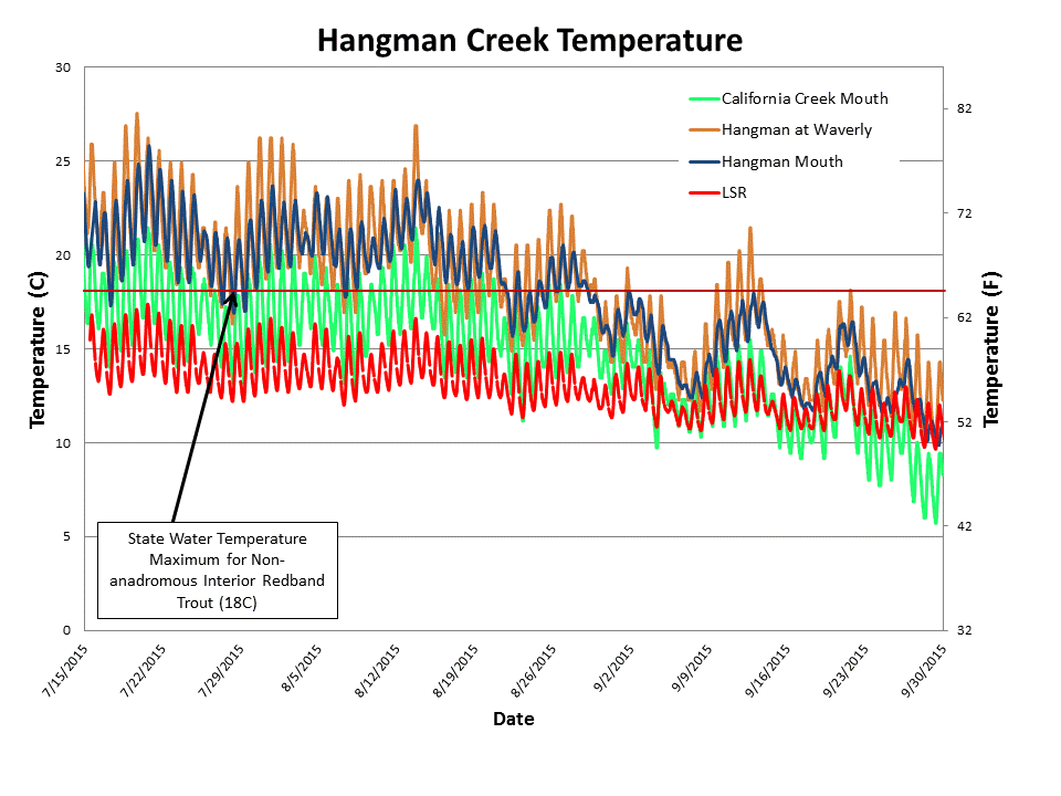
- Water temperatures in Hangman Creek are highest at our logger in the Palouse area (Waverly) and much too high for trout both there and at the mouth, while California Creek may contain a cool water refuge.
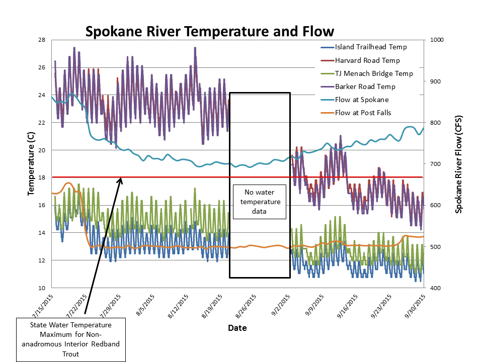
- Water temperatures in the Spokane River at Barker and Harvard Road are much too high for trout this summer. Areas downstream of these locations saw cool temperatures suitable for trout.
- Decreasing the flow Spokane River at Post Falls from 600 to 500 cubic feet per second (cfs) causes a measurable decrease in water temperatures of the River at Islands Trailhead (near Plante's Ferry).
Our methods were simple. We placed our Hobo temperature loggers in 6" segments of white PVC tubing to shield them from the sun, secured them to a nearby tree with twine or cable, and submerged them in about 2-3 feet of water in a secluded location. The loggers read water temperature every 30 minutes, and aside from a two week hiatus, from July 15th to September 30th.
Our data showed temperatures in Hangman Creek exceed the state maximum for non-anadromous interior Redband Trout of 18 C (64 F). The graph below charts water temperature in Hangman Creek and the Little Spokane River, with temperature on the Y-axes in Celsius and Fahrenheit. The temperature at Waverly regularly exceeds 25 C (77 F), and on one day reached over 27 C (81 F)! Water temperature at the mouth of Hangman Creek was a bit lower, but remained mostly above the 18 C (64 F) mark for about a month. Interestingly, water temperature at Waverly tends to fluctuate more than at the mouth of Hangman Creek, possibly reflecting the lack of riparian buffer in the Palouse. Riparian buffer, the vegetated area along a stream, shades the creek. In the Palouse, riparian buffers have been torn out long ago in lieu of agriculture, leaving streams open to direct sunlight.
I monitored water temperature California Creek as well, which is a relatively intact stream (relative to upper Hangman ), with healthy riparian buffers in the lower portion of the creek. Water temperature here was much lower, and daily minimum temperatures fell below the 18 C (64 F)mark. Lacking any input from groundwater that I am aware of, California Creek's temperatures reflect the partially intact nature of its watershed. Lastly, Ian Townley, my colleague at St. George's School, monitored water temperatures in the Little Spokane River. Temperatures here were much lower than Hangman Creek during the hot summer months and never exceeded the 18 C mark. This is a reflection of the cold aquifer water running into the River and the intact nature of portions of this watershed.
Our Spokane River temperature data is graphed below, with water temperature and Spokane River flow on the left and right y-axes, respectively. As I wrote about earlier, the reduction of flow at Post Falls on 7/18/15 seemed to reduce the temperature at Island Trailhead. After the hot summer air temperatures ended, water temperatures reacted accordingly, dropping down by about 5 C (9 F) during the two week period we did not have loggers in the water.

Our water temperature studies this summer reveal temperatures in the Spokane River and Hangman Creek that are much too hot for our native redband trout. Trout, our "canary in a coal mine", indicate cool, clean water and a healthy ecosystem. The high water temperatures we found this year reflect the state of our streams and rivers in the Inland Northwest, which in many cases lack riparian buffers and other common sense measures that improve water quality. The health of our streams depend on reestablishing riparian buffers in areas they have been removed, most of which are areas of intensive agriculture.


